
“We just need to let you know that this is the last night the campground will be open for the season, due to the plague,” the host advised from her drive thru check in booth. She reached out her window, handing me a packet of papers. “We are required to give you this information about the plague.”
I’ll admit, I didn’t know what exactly the plague was. I thought it was just a very generic term used to describe a sickness that spread quickly, or that it was some sort of medieval illness. What was she doing talking about the plague here at Lake Tahoe?
“Just make sure you stay away from rodents, especially any dead ones.” My mind flashed back to the dead squirrel laying beside my tent in Great Basin National Park. After the first night camping there, it was gone. Some animal must have come for it in the night, when I was sound asleep.
“Is it still safe to camp here?” I inquired.
“Well, there haven’t been any cases of human infection yet, but as a precaution we are closing down tomorrow, and they will start treating the area.”
She proceeded to tell me where my campsite was, and I drove slowly to my site. The Lake Tahoe region was the most difficult place to secure a campsite of this entire trip. I spent a great deal of time searching online for a campground with vacancy. This was Fallen Leaf Campground at South Lake Tahoe, part of the U.S. Forest Service’s Tahoe Recreation Area. This campground was large, with many loops, but few campers remained. I pulled up to my site, and as first order of business, I read the handouts about the plague. I learned it was a bacterial infection transmitted by rodents and fleas. Although it can be fatal, it just starts with common flu like symptoms and can be treated successfully when detected early enough.
 I knew I wouldn’t be in contact with rodents. It’s not in my liking to approach them, unless we are talking about an adorable golden-mantled ground squirrel posing for a picture in Bryce Canyon. Apart from that I didn’t foresee rodents being a concern. But fleas, on the other hand, well, I didn’t know a lot about flees except that they were insects and insects get around. So I stepped out of my car and drenched myself in deet, and then I soon forgot that the Plague was even an issue. I set up my tent in the company of tall pines. In the distance between the pines I could see the snow capped mountains of the Sierra Nevada. When camp was set up, I walked across the smooth paved campground road to a general store on the grounds. I wanted to inquire about the coin showers. I exchanged my dollars for coins, enough for me to have two complete shower cycles.
The campground shower facilities were very nice. Each shower was accessed from an outside door. Inside there was also a toilet, sink, mirror, and electrical outlets. Everything I could ask for in a bathroom was there. I was excited, for it had been a week since I last showered.
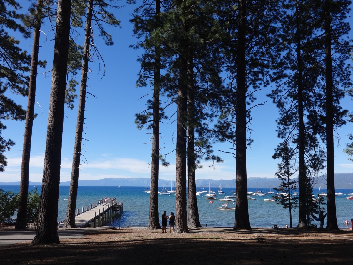
When I was all clean and feeling refreshed, I put on my swimsuit, tank top, and flip flops, and I walked a paved pathway through the forest about a mile to Lake Tahoe. I arrived and the place was busy. There was some sort of open air restaurant and bar next to the water, and many families and couples walked about and lounged on the beach.
Lake Tahoe is refreshingly beautiful, especially after having spent the past few days in the dry desert expanse of Nevada. The tall pine forest led right up to the sand where the clearest water I’ve ever seen laped against the shore. Across the twenty-two miles of shimmering blue were the snow capped mountains of the northern Sierra Nevada. I never went out on a boat into Lake Tahoe but there are so many ways to enjoy Lake Tahoe from land. You can look down on it from an overlook of the road. There it is spread out underneath the tree line, and you can look down not just upon it, but straight through it, getting a preview of how deep it is. From here you can also observe all the coves and inlets where the lake turns to hide and rest.
 Another way to enjoy Lake Tahoe is what I was doing that evening from the sand of one of its many beaches, feeling like I’d made to the ocean and had become a beach bum while at the same time looking up at the snow capped mountains feeling like a northern mountaineer.
I went out on a dock, and looking down the crystal clear water gave me a sensation I’d never quite felt before, almost a sort of dizziness. I’ve never been able to look straight down a lake before, vision unobstructed, where I could see fish swimming around at different depths, and the sand and pebbles laying untouched at the bottom. I would not take someone out here who is afraid of heights, because even though you are nearly level to the water, you are actually high up from the ground underneath, and you can see that so clearly. Despite the peculiar sensation, at the same time, it was miraculously beautiful. Beauty like this is not happenstance. It’s created.

 A final way I enjoyed Lake Tahoe was from one of the porches of the Baldwin and Pope Estates. There, just next to the trail I arrived on, and set up behind the beach, were these two estates, preserved as the Tallac Historic Site, managed by the U.S. Forest Service. The estates contained a collection of houses built in the late 1800s and early 1900s that were the private resorts for three social elite families of the San Francisco Bay Area. All of these buildings were composed of wood fashioned in one way or another, blending this rustic north woods style with tudor elements. The estates included the large summer cottages, accompanied with dark wooden shingles, and numerous guest houses and small log cabins for the tutor, groundskeepers, and servants. They were all tied together by well kept pathways and gardens. During the day, the buildings were open for tours, but I was there in the evening. They were all closed, but people were free to explore the grounds.
I sat on the porch of the main Pope cottage, in a rocking chair. I looked out the frame of the porch structure through the dark pines to the bright blue of the lake and the mountains beyond. I imagined, just for a moment, that this was my house. I took it all in. Just a matter of hours ago, I was in a ghost town off Highway 50 in the relentless desert sun. Now, I was sitting on the porch of a wealthy estate, in the shade of the sweet pines, looking out at a marvelous view. It was very relaxing. And it was all a pleasant surprise. I didn’t know these estates of Tallac Historic Site existed, and I thought it was so novel and welcoming to be able to enjoy the elite life freely for a moment on this porch.
When the evening grew old, my wandering around Lake Tahoe for the day became complete, and my moment of an elitists life came to a screeching halt, as I decided to grab a bite to eat at Taco Bell and visit the local Kmart.
Driving into to Lake Tahoe on the southern end, I wasn’t impressed by the surrounding area. There were numerous casinos, tacky hotels, untasteful restaurants, and noisy traffic. Of course all things of the civilized world seem extra distasteful after having spent so much time out in the nature in the wild expanse of the Great Basin. My first impression of the area, was certainly, however, not favorable, but my campground, so nicely situated with a short walk from the beach and the beautiful estates, with the stunning and relaxing view of the lake, gave me a very favorable memory of Lake Tahoe. I would return the next morning to the lake, to lay in the sun, read from my book about the West, and enjoy the beautiful view of Tallac and Taylor Creeks flowing into the Lake as silver ribbons.
This is one of those places, that would have made a great National Park, but commerce and private ownership moved in too quickly and much of the surrounding area was lost to commercial tourist consumption and casino tycoons, but, as I discovered, the U.S. Forest service does have a hold on these pockets of beauty around the lake, and I was very fortunate to discover one and also fortunate to leave without contracting the plague.
Given the opportunity, I would definitely go back and visit Lake Tahoe again.
Read the next entry, “The Golden Gate National Parks,” here: https://joshthehodge.wordpress.com/2018/04/06/golden-gate-national-parks
Read the previous entry, “How I relate to Ghost Towns,” here: https://joshthehodge.wordpress.com/2018/04/04/how-i-relate-to-ghost-towns/
Facebook: http://facebook.com/joshua.hodge
Instagram: http://www.instagram.com/joshthehodge/

 A band of wild horses galloped through the sagebrush to my left. To my right, the dirt road crumbled off into a ravine. The sun was bright and hot, and I was out here by myself. If something happens to my car, I’m done for. Stranded in the scorching desert miles from anybody, this would be it. I had taken the unnamed and barely marked road from America’s Loneliest Highway, Highway 50, further into the remoteness of Nevada, seeking the ghost town of Hamilton.
  Eventually the hills gave way to a wide valley, and I came upon the ruins of Hamilton. The ruins were largely spread out and very diverse. I parked my car over to the side of the dirt road and I first came upon the remnants of a stone house. Slates of stone had been stacked ontop each other to create a building, but now only two adjacent walls remained.
  One had an arched doorway still in tact that was held in place by bricks seeming to defy the laws of gravity. In the near vicinity were other ruins of stone houses left barely recognizable, in piles of rock. Further in, I came upon some wooden structures. There were two buildings completely dilapidated except for their roofs just laying on the ground pointing upward.
 building within the building had ominously broken glass windows. I looked up and the roof of the warehouse had holes every so often, evenly distributing light throughout the building. To me the place seemed to be an abandoned repair garage. The concrete floor was dusty and dirty and large empty tanks, tin barrels, and appliances littered the floor. I took a few steps in slowly.
  To add to the creepiness of the place, leaving the warehouse, I walked over to a small one room wooden shack, where in the doorframe hung a noose. What is going on? First an ominous warehouse, then a raven giving warning, and now a noose hung from a door frame.
 My last stop in Hamilton was at the Hamilton Cemetery. Tombstones were dated from the 1870s to 1890s. One portion of the cemetery was enclosed in a gothic style short steel fence, something that looked like it had come right out of the backyard of Disney’s Haunted Mansion.
 Looking at them, you wouldn’t guess their age. They are rather girthy, but not that tall in comparison to something like the Sequoia or Redwood, which we often equate with age. Their branches are unique as they twist and curve like strings of warm taffy. Once you fully consider how old they are, they start to look elderly. Their exterior is painted many different shades of brown, and the trunks and limbs are brushed with indentations and grooves, like a wrinkly old man who’s spent too many days out in the sun. At the same time, the way they look is almost fanciful. Although extremely still and sturdy, the dramatic twisted growth and exotic posture make these trees appear frozen in mid-dance, manipulated by some strange sorcery.

 I stood there in a prairie along the mountain side, among bunchgrass and black sage, looking up at the mountain peek. The view looked like Wheeler Peak, and the adjoining peaks, used to all be connected at a higher point, all composing one grand mountain, but over time that higher summit crumbled to pieces and formed the rock glacier. Nevertheless, Wheeler Peak stands very tall. It’s Nevada’s highest peak. Although just summiting the beast alone seemed impossible, one of my questions was, do I have time? I was not getting an early start. It was well into the afternoon.
  Eventually there was nothing left except me on the slanted fields of rock crumble. The trail evolved into switchbacks, and since the landscape was so uniform, it was difficult at times to know exactly where the trail was supposed to be.
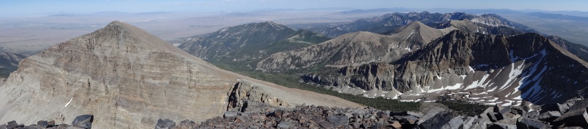 When I reached the top, the wind had dissipated greatly. I was stunned by the view. Hundreds of miles of Nevada was visible in all directions. Here I could truly see just how mountainous Nevada was, with mountains all over in near and far reaches, with sharp points, and slanted slopes, snow caps, and hidden forests, and valleys of desert between them all, covering great expanses. Just across from Wheeler peak was another peak that rose on a mountain which looked like it had been sliced by a knife with such a shark direct cut down to its base.